
The provincial government has posted a map showing the risk levels for sinkholes across Nova Scotia.
John Drage, senior geologist with the department of energy and mines, explained Karst is the 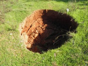 term used by geologists to describe areas where there are numerous sinkholes caused by water soluble rock like gypsum and limestone. Drage said the map shows Antigonish, Pictou, Guysborough, Inverness and Richmond counties have varying risks of sinkholes. He said there are areas particularly around Antigonish County and the West coast of Cape Breton where there are numerous sinkholes present.
Drage noted designating an area as high risk doesn’t mean sinkholes will appear all of a sudden but rather those areas are where sinkholes may occur eventually, especially if storm water concentrates in one place. Generally the number of sinkhole occurring in the high risk areas in one per 100 square kilometres. Things like storm water management can help reduce the risk of sinkhole occurring.
Drage said the easiest way to find and see the interactive map is to Google search sinkholes Nova Scotia and it will be located on the government of Nova Scotia website.